
Town of Catskill topographic map
Interactive map
Click on the map to display elevation.
About this map
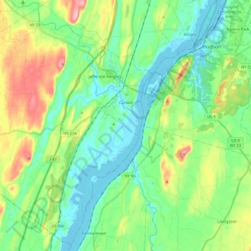
Name: Town of Catskill topographic map, elevation, terrain.
Average elevation: 59 m
Minimum elevation: -4 m
Maximum elevation: 203 m
Other topographic maps
Click on a map to view its topography, its elevation and its terrain.
Kaaterskill High Peak
États-Unis d'Amérique > New York > Greene County > Town of Hunter
Kaaterskill High Peak, Town of Hunter, Greene County, New York, 12436, États-Unis d'Amérique
Average elevation: 850 m
Catskill
États-Unis d'Amérique > New York > Greene County > Catskill
Catskill, Town of Catskill, Greene County, New York, États-Unis d'Amérique
Average elevation: 19 m