
Make a donation
Gear up for your next adventure:
As an Amazon Associate, this site earns from qualifying purchases at no extra cost to you.
Inverkeithing topographic map
Click on the map to display elevation.
Make a donation
Gear up for your next adventure:
As an Amazon Associate, this site earns from qualifying purchases at no extra cost to you.
Inverkeithing
Topographically, Inverkeithing is situated on a raised terrace sloping down towards Inverkeithing Bay, which cuts in to the south of the town, separating it from the North Queensferry peninsula. There are views from the town centre across the Firth of Forth to Edinburgh, Arthur's Seat, and the Pentland Hills.
Make a donation
Gear up for your next adventure:
As an Amazon Associate, this site earns from qualifying purchases at no extra cost to you.
About this map
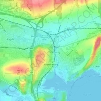
Name: Inverkeithing topographic map, elevation, terrain.
Location: Inverkeithing, Fife, Scotland, United Kingdom (56.01937 -3.40889 56.05128 -3.36979)
Average elevation: 28 m
Minimum elevation: -5 m
Maximum elevation: 91 m
Make a donation
Gear up for your next adventure:
As an Amazon Associate, this site earns from qualifying purchases at no extra cost to you.
Other topographic maps
Click on a map to view its topography, its elevation and its terrain.
Kirkcaldy
United Kingdom > Scotland > Fife
Towards the end of the 16th century, a detailed assessment on the size of the townscape was carried out. The first estimate of the parish population in 1639 was between 3,000 and 3,200 and around 3,400 by 1691. At the beginning of the 18th century, the population declined. A census by Webster's Topographical…
Average elevation: 50 m