
Howard County topographic map
Interactive map
Click on the map to display elevation.
About this map
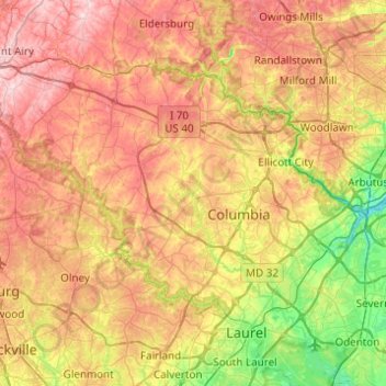
Name: Howard County topographic map, elevation, terrain.
Location: Howard County, Maryland, USA (39.10306 -77.18698 39.36954 -76.69636)
Average elevation: 128 m
Minimum elevation: 2 m
Maximum elevation: 266 m
Other topographic maps
Click on a map to view its topography, its elevation and its terrain.
Severn River
USA > Maryland > Epping Forest
Severn River, Severn Road, Parole, Epping Forest, Anne Arundel County, Maryland, 21405, USA
Average elevation: 13 m
Kingsville
USA > Maryland > Kingsville
Kingsville, Baltimore County, Maryland, 21087, USA
Average elevation: 83 m
Sue Island
Sue Island, Towson, Baltimore County, Maryland, 21220-5203, USA
Average elevation: 47 m
Savage River
Savage River, Garrett County, Maryland, 21523, USA
Average elevation: 687 m
Henrys Bridge
USA > Maryland > Henrys Bridge
Henrys Bridge, Baltimore County, Maryland, 21131, USA
Average elevation: 165 m
Grahams Green Acres
USA > Maryland > Grahams Green Acres
Grahams Green Acres, Carroll County, Maryland, 21776, USA
Average elevation: 223 m
Swainson Island
Swainson Island, Cabin John, Montgomery County, Maryland, USA
Average elevation: 52 m
Sugarloaf Mountain
Sugarloaf Mountain, Frederick County, Maryland, 20842, USA
Average elevation: 200 m