
Mértola topographic map
Interactive map
Click on the map to display elevation.
About this map
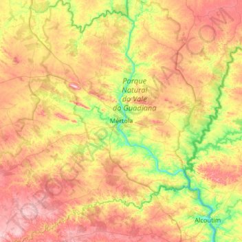
Name: Mértola topographic map, elevation, terrain.
Location: Mértola, Beja, Portugal (37.43200 -7.93417 37.84941 -7.42635)
Average elevation: 162 m
Minimum elevation: 0 m
Maximum elevation: 354 m
Other topographic maps
Click on a map to view its topography, its elevation and its terrain.
Ribeira dos Lameiros
Ribeira dos Lameiros, São Luís, Odemira, Beja, Portugal
Average elevation: 107 m
Corte Gafo de Cima
Portugal > Beja > Mértola > Corte Gafo de Cima
Corte Gafo de Cima, Mértola, Beja, 7750-308, Portugal
Average elevation: 166 m