
Make a donation
Gear up for your next adventure:
As an Amazon Associate, this site earns from qualifying purchases at no extra cost to you.
Silver Star topographic map
Click on the map to display elevation.
Make a donation
Gear up for your next adventure:
As an Amazon Associate, this site earns from qualifying purchases at no extra cost to you.
About this map
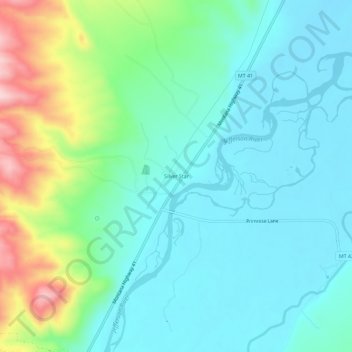
Name: Silver Star topographic map, elevation, terrain.
Location: Silver Star, Madison County, Montana, 59751, United States (45.67024 -112.30306 45.71024 -112.26306)
Average elevation: 1,428 m
Minimum elevation: 1,365 m
Maximum elevation: 1,623 m
Make a donation
Gear up for your next adventure:
As an Amazon Associate, this site earns from qualifying purchases at no extra cost to you.
Other topographic maps
Click on a map to view its topography, its elevation and its terrain.
Axolotl Lakes Wilderness Study Area
United States > Montana > Madison County
Average elevation: 2,351 m
Make a donation
Gear up for your next adventure:
As an Amazon Associate, this site earns from qualifying purchases at no extra cost to you.