
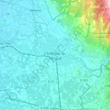
L'Isle-sur-la-Sorgue topographic map
Interactive map
Click on the map to display elevation.
About this map
Name: L'Isle-sur-la-Sorgue topographic map, elevation, terrain.
Average elevation: 87 m
Minimum elevation: 46 m
Maximum elevation: 415 m
Other topographic maps
Click on a map to view its topography, its elevation and its terrain.
Apt
Frankreich > Provence-Alpes-Côte d'Azur > Vaucluse > Apt
Apt, Vaucluse, Provence-Alpes-Côte d'Azur, Metropolitanes Frankreich, 84400, Frankreich
Average elevation: 358 m
Vaison-la-Romaine
Frankreich > Provence-Alpes-Côte d'Azur > Vaucluse
Vaison-la-Romaine, Carpentras, Vaucluse, Provence-Alpes-Côte d'Azur, Metropolitanes Frankreich, 84110, Frankreich
Average elevation: 286 m