
Osterode am Harz topographic map
Interactive map
Click on the map to display elevation.
About this map
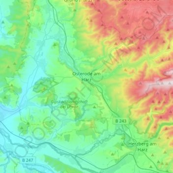
Name: Osterode am Harz topographic map, elevation, terrain.
Average elevation: 304 m
Minimum elevation: 131 m
Maximum elevation: 755 m
Other topographic maps
Click on a map to view its topography, its elevation and its terrain.
Lerbach
Germany > Lower Saxony > Landkreis Göttingen > Osterode am Harz
Lerbach, Osterode am Harz, Landkreis Göttingen, Lower Saxony, 37520, Germany
Average elevation: 381 m
Abt. 84A
Germany > Lower Saxony > Landkreis Göttingen > Göttingen
Abt. 84A, Stadtfriedhof, Weststadt, Göttingen, Landkreis Göttingen, Lower Saxony, 37081, Germany
Average elevation: 156 m