
Tivoli topographic map
Interactive map
Click on the map to display elevation.
About this map
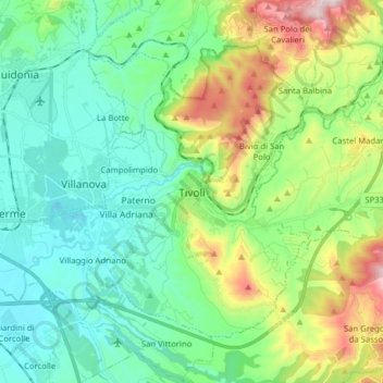
Name: Tivoli topographic map, elevation, terrain.
Location: Tivoli, Roma Capitale, Lazio, Italy (41.91668 12.68992 42.00607 12.84776)
Average elevation: 234 m
Minimum elevation: 21 m
Maximum elevation: 815 m
Other topographic maps
Click on a map to view its topography, its elevation and its terrain.