
Lagares topographic map
Interactive map
Click on the map to display elevation.
About this map
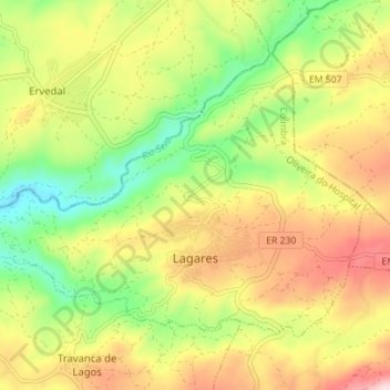
Name: Lagares topographic map, elevation, terrain.
Location: Lagares, Oliveira do Hospital, Coimbra, Portugal (40.38869 -7.90206 40.42741 -7.83197)
Average elevation: 355 m
Minimum elevation: 217 m
Maximum elevation: 511 m
Other topographic maps
Click on a map to view its topography, its elevation and its terrain.
Vila do Mato
Portugal > Coimbra > Tábua > Midões
Vila do Mato, Midões, Tábua, Coimbra, 3420-149, Portugal
Average elevation: 269 m
Cabril
Portugal > Coimbra > Pampilhosa da Serra
Cabril, Pampilhosa da Serra, Coimbra, Portugal
Average elevation: 680 m