
Qom Province topographic map
Interactive map
Click on the map to display elevation.
About this map
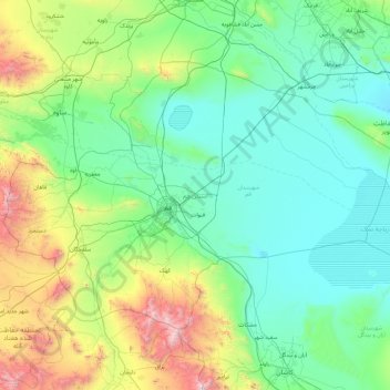
Name: Qom Province topographic map, elevation, terrain.
Location: Qom Province, Iran (34.15818 50.08620 35.21861 51.96490)
Average elevation: 1,207 m
Minimum elevation: 775 m
Maximum elevation: 3,427 m
Other topographic maps
Click on a map to view its topography, its elevation and its terrain.
Gold
Iran > Chaharmahal and Bakhtiyari Province > Lordegan County > Sardasht Rural District
Average elevation: 1,739 m
Now
Iran > Chaharmahal and Bakhtiyari Province > Lordegan County > Sardasht Rural District
Average elevation: 1,871 m
Shurab
Iran > South Khorasan Province > Birjand County > دهستان شاخن > Foorjan
Average elevation: 1,935 m
Espakeh
Iran > Sistan and Baluchestan Province > Lashar County > دهستان لاشارشمالی
Average elevation: 776 m
Shalan
Iran > Kermanshah Province > Kermanshah County > (هوره سو)دهستان قره سو
Average elevation: 1,515 m
Tabriz
Iran > East Azerbaijan Province > Tabriz
Tabriz (Persian: تبریز (listen); Azerbaijani: تبریز) is the most populated city in northwestern Iran, one of the historical capitals of Iran and the present capital of East Azerbaijan province. It is the sixth most populous city in Iran. Located in the Quru River valley, in Iran's historic…
Average elevation: 1,594 m
Qom
Iran > Qom Province > Qom
The city's topography in the 10th century still reflected the evolutionary merging of the original six villages; these were still separated by fields. The town center was located in the village of Mamajjān, which was connected to other parts of the city on the other side of the river by four bridges. There…
Average elevation: 959 m
Kerrawa
Iran > Kurdistan Province > Sarvabad County > دهستان رزآب > Kerrawa
Average elevation: 1,426 m
Sib
Iran > Sistan and Baluchestan Province > Sib and Suran County > دهستان سیب وسوران > Sib
Average elevation: 1,146 m