
Can Gio District topographic map
Interactive map
Click on the map to display elevation.
About this map
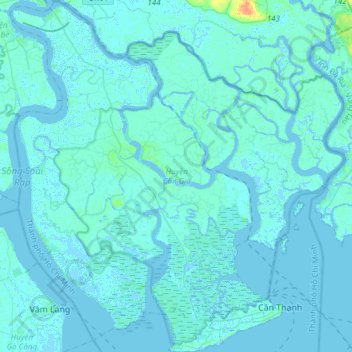
Name: Can Gio District topographic map, elevation, terrain.
Location: Can Gio District, Ho Chi Minh City, Vietnam (10.37617 106.73820 10.67519 107.02767)
Average elevation: 2 m
Minimum elevation: -5 m
Maximum elevation: 30 m
Other topographic maps
Click on a map to view its topography, its elevation and its terrain.
Ho Chi Minh City
Ho Chi Minh City is located in the south-eastern region of Vietnam, 1,760 km (1,090 mi) south of Hanoi. The average elevation is 19 metres (62 ft) above sea level. It borders Tây Ninh Province and Bình Dương Province to the north, Đồng Nai Province and Bà Rịa–Vũng Tàu Province to the east, Long…
Average elevation: 6 m