
Xiangning County topographic map
Interactive map
Click on the map to display elevation.
About this map
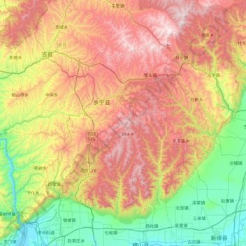
Name: Xiangning County topographic map, elevation, terrain.
Location: Xiangning County, Linfen, Shanxi, China (35.68929 110.50663 36.14994 111.28696)
Average elevation: 977 m
Minimum elevation: 376 m
Maximum elevation: 1,804 m
The county is located in the Lüliang Mountains of the Loess Plateau, and has a largely hilly terrain with an average elevation of about 900 metres (3,000 ft). The county's highest point is Gaotian Mountain (Chinese: 高天山), which reaches 1,820.5 metres (5,973 ft) in altitude; the county's lowest point is along the banks of the Yellow River, at 385.1 metres (1,263 ft) in altitude.
Other topographic maps
Click on a map to view its topography, its elevation and its terrain.
Qingxu County
China > Shanxi > Qingxu County
Qingxu County, Taiyuan City, Shanxi, China
Average elevation: 913 m
Gujiao City
China > Shanxi > Gujiao City
Gujiao City, Taiyuan City, Shanxi, China
Average elevation: 1,379 m
Taiyuan
China > Shanxi > Taiyuan > Sanqiao Subdistrict
Taiyuan, Sanqiao Subdistrict, Xinghualing District, Taiyuan City, Shanxi, 030002, China
Average elevation: 982 m