
Make a donation
Gear up for your next adventure:
As an Amazon Associate, this site earns from qualifying purchases at no extra cost to you.
Neuried topographic map
Click on the map to display elevation.
Make a donation
Gear up for your next adventure:
As an Amazon Associate, this site earns from qualifying purchases at no extra cost to you.
Neuried
Das von dem Münchner Architekten Andreas Meck geplante katholische Pfarrzentrum St. Nikolaus wurde 2008 der Gemeinde übergeben. Rudolf Bott gestaltete die aus Beton gegossene Altarinsel. Ein von Andreas Meck konzipiertes sphärisches Kreuz, dessen Höhe und Breite 15 Meter beträgt, wurde 2009 vor dem Pfarrzentrum aufgestellt.
Make a donation
Gear up for your next adventure:
As an Amazon Associate, this site earns from qualifying purchases at no extra cost to you.
About this map
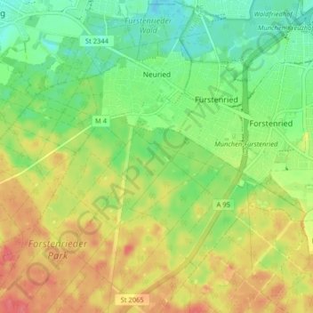
Name: Neuried topographic map, elevation, terrain.
Location: Neuried, Landkreis München, Bayern, 82061, Deutschland (48.05216 11.40219 48.10583 11.47634)
Average elevation: 570 m
Minimum elevation: 541 m
Maximum elevation: 605 m
Make a donation
Gear up for your next adventure:
As an Amazon Associate, this site earns from qualifying purchases at no extra cost to you.
Other topographic maps
Click on a map to view its topography, its elevation and its terrain.
Hailafing
Deutschland > Bayern > Landkreis München
Beigarten | Deigstetten | Ebertshausen | Epolding | Frundsbergerhöhe | Gleißentalweiher | Großdingharting | Hailafing | Holzhausen | Kirchlberg | Kleindingharting | Mühlthal | Straßlach
Average elevation: 637 m
Beigarten
Deutschland > Bayern > Landkreis München > Straßlach-Dingharting > Beigarten
Average elevation: 625 m
Make a donation
Gear up for your next adventure:
As an Amazon Associate, this site earns from qualifying purchases at no extra cost to you.
Make a donation
Gear up for your next adventure:
As an Amazon Associate, this site earns from qualifying purchases at no extra cost to you.
Deisenhofen
Deutschland > Bayern > Landkreis München > Oberhaching
Das Pfarrdorf liegt direkt südlich des Ortsteils Oberhaching am Nordende des Gleißentals auf einer Höhe von 595 m. In dem Ort tritt das durch das Gleißental fließende Grundwasser zutage und bildet den Hachinger Bach.
Average elevation: 592 m
Make a donation
Gear up for your next adventure:
As an Amazon Associate, this site earns from qualifying purchases at no extra cost to you.
Make a donation
Gear up for your next adventure:
As an Amazon Associate, this site earns from qualifying purchases at no extra cost to you.
Make a donation
Gear up for your next adventure:
As an Amazon Associate, this site earns from qualifying purchases at no extra cost to you.
Make a donation
Gear up for your next adventure:
As an Amazon Associate, this site earns from qualifying purchases at no extra cost to you.
Make a donation
Gear up for your next adventure:
As an Amazon Associate, this site earns from qualifying purchases at no extra cost to you.
Make a donation
Gear up for your next adventure:
As an Amazon Associate, this site earns from qualifying purchases at no extra cost to you.
Haar
Deutschland > Bayern > Landkreis München > Haar > Haar
Das Haarer Trinkwasser wurde zunächst in Brunnen am Rande des Gemeindegebietes gefördert. Um die Versorgung des wachsenden Ortes auch für die Zukunft langfristig zu sichern, wurden neue Quellen erschlossen. So stammt seit 2011 das geförderte Wasser aus einem Gebiet im Höhenkirchener Forst, in dem das…
Average elevation: 543 m
Make a donation
Gear up for your next adventure:
As an Amazon Associate, this site earns from qualifying purchases at no extra cost to you.
Make a donation
Gear up for your next adventure:
As an Amazon Associate, this site earns from qualifying purchases at no extra cost to you.