Geolocate

Georgetown topographic map

Click on the map to display elevation.

About this map

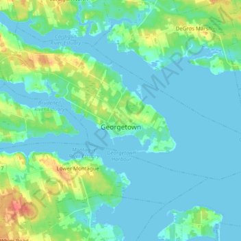
Name: Georgetown topographic map, elevation, terrain.

Location: Georgetown, Town of Three Rivers, Kings County, Prince Edward Island, Canada (46.16168 -62.55837 46.21357 -62.47498)

Average elevation: 7 m

Minimum elevation: -2 m

Maximum elevation: 38 m

Other topographic maps

Click on a map to view its topography, its elevation and its terrain.

Dundee

Canada > Prince Edward Island > Kings County

Average elevation: 24 m

Gear up for your next adventure:

Outdoor Coffee Makers - Enjoy quality coffee at the summit of your favorite peak
🍳Camping Cookware - Cookware sets for outdoor meals
🌬️Windbreaker Jackets - Wind protection jackets
🔭Compact Hiking Binoculars - Lightweight optics for scouting routes or birdwatching
🧦Merino Wool Hiking Socks - Moisture-wicking socks to prevent blisters during long topographic surveys

As an Amazon Associate, this site earns from qualifying purchases at no extra cost to you.