
Make a donation
Gear up for your next adventure:
As an Amazon Associate, this site earns from qualifying purchases at no extra cost to you.
Fort Mountain topographic map
Click on the map to display elevation.
Make a donation
Gear up for your next adventure:
As an Amazon Associate, this site earns from qualifying purchases at no extra cost to you.
Fort Mountain
On June 20, 1944, a C-54-A cargo plane on the Newfoundland to Washington, D.C. leg of trans-Atlantic TWA Flight 277 from England was pushed 70 miles (110 km) north of its planned course by stormy weather, which prevented obtaining visual or radio location fixes. The crew was unaware the aircraft had entered mountainous terrain and was still flying at the 4,000-foot (1,200 m) elevation appropriate for passing over Bangor, Maine. The single passenger and all six crewmen were killed when the aircraft hit Fort Mountain. The aircraft burned, but some large pieces are still accessible and reasonably well preserved.
Make a donation
Gear up for your next adventure:
As an Amazon Associate, this site earns from qualifying purchases at no extra cost to you.
About this map
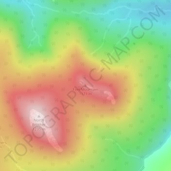
Name: Fort Mountain topographic map, elevation, terrain.
Average elevation: 944 m
Minimum elevation: 668 m
Maximum elevation: 1,248 m
Make a donation
Gear up for your next adventure:
As an Amazon Associate, this site earns from qualifying purchases at no extra cost to you.