
Mountain Creek topographic map
Interactive map
Click on the map to display elevation.
About this map
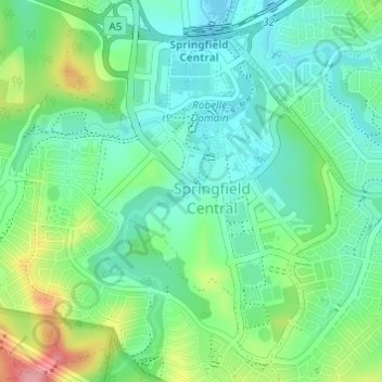
Name: Mountain Creek topographic map, elevation, terrain.
Location: Mountain Creek, Ipswich, Queensland, 4300, Australia (-27.68566 152.90216 -27.68559 152.90226)
Average elevation: 78 m
Minimum elevation: 41 m
Maximum elevation: 163 m
Queensland trails, hiking, mountain biking, running and outdoor activities
Other topographic maps
Click on a map to view its topography, its elevation and its terrain.