Tolland County topographic map
Interactive map
Click on the map to display elevation.
About this map
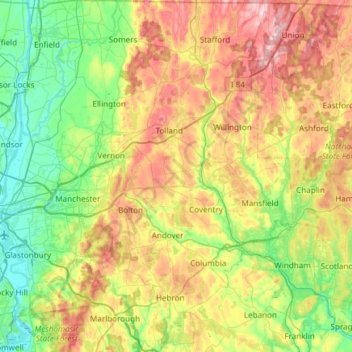
Name: Tolland County topographic map, elevation, terrain.
Location: Tolland County, Connecticut, USA (41.58855 -72.51864 42.03438 -72.09962)
Average elevation: 140 m
Minimum elevation: 0 m
Maximum elevation: 398 m
Other topographic maps
Click on a map to view its topography, its elevation and its terrain.
Cromwell
USA > Connecticut > Cromwell
Cromwell, Middlesex County, Connecticut, 06480, USA
Average elevation: 31 m
Branford Hills
USA > Connecticut > Branford Hills
Branford Hills, New Haven County, Connecticut, 06512, USA
Average elevation: 12 m
Milford
USA > Connecticut > Milford
Milford, New Haven County, Connecticut, USA
Average elevation: 17 m
White Mountain
White Mountain, Middlesex County, Connecticut, 06456, USA
Average elevation: 59 m
Torrington
USA > Connecticut > Torrington
Torrington, Litchfield County, Connecticut, 06790, USA
Average elevation: 303 m
Mount Archer
Mount Archer, New London County, Connecticut, 06371:06423, USA
Average elevation: 69 m
Major Island
Major Island, New London County, Connecticut, USA
Average elevation: 16 m