
Wonosobo topographic map
Interactive map
Click on the map to display elevation.
Wonosobo
Wonosobo has an elevation moderated tropical rainforest climate (Af) with moderate rainfall from July to September and heavy to very heavy rainfall in the remaining months. The following climate data is for the town of Wonosobo.
About this map
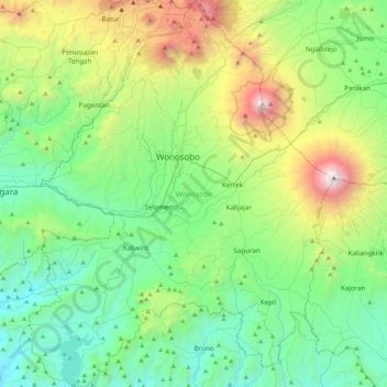
Name: Wonosobo topographic map, elevation, terrain.
Location: Wonosobo, Central Java, Java, Indonesia (-7.61240 109.73715 -7.18719 110.07421)
Average elevation: 876 m
Minimum elevation: 34 m
Maximum elevation: 3,308 m
Other topographic maps
Click on a map to view its topography, its elevation and its terrain.