
Fingal topographic map
Interactive map
Click on the map to display elevation.
About this map
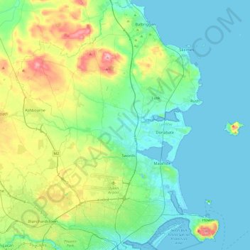
Name: Fingal topographic map, elevation, terrain.
Location: Fingal, County Dublin, Leinster, Ireland (53.35349 -6.47504 53.63471 -5.99450)
Average elevation: 39 m
Minimum elevation: -1 m
Maximum elevation: 175 m
Other topographic maps
Click on a map to view its topography, its elevation and its terrain.
Blanchardstown
Blanchardstown was a predominantly rural area, with a small village, in western County Dublin, alongside the neighbouring district of Castleknock. Both areas shared a common history until well into the 19th century, when their development diverged. In A Topographical Dictionary of Ireland, published in 1837,…
Average elevation: 61 m
Castleknock
As the word Castle did not come into use in Ireland until Norman times we know that Castleknock is a name of comparatively recent origin. Documents from the 12th and 13th centuries refer to the place as Castrum Cnoc, simply Cnoc and also Chastel-cnoc or Castel-Cnoc.[8] So it seems that the name Castleknock is…
Average elevation: 55 m
Swords
Ireland > County Dublin > Swords
At the northern end of the street stands Swords Castle, 200m northeast of the ecclesiastical site, which was built in the early 13th century. A short distance north of the castle is the elevation known as Spittal Hill, where a hospital once stood.
Average elevation: 28 m