
Pemalang topographic map
Interactive map
Click on the map to display elevation.
Pemalang
The regency has a varied topography. The northern part of the regency is a coastal area with an altitude ranging from 1 to 5 metres above sea level. The central part is a fertile lowland with an altitude of 6 to 15 metres above sea level; and the southern highlands and mountains are lush with cool air at an altitude varying from 16 to 925 metres above sea level. The region is crossed by two major rivers – the Waluh River and the Comal River. Most of the region is a fertile watershed.
About this map
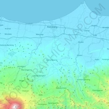
Name: Pemalang topographic map, elevation, terrain.
Location: Pemalang, Central Java, Java, Indonesia (-7.24889 109.18559 -6.77331 109.59920)
Average elevation: 295 m
Minimum elevation: -1 m
Maximum elevation: 3,408 m
Other topographic maps
Click on a map to view its topography, its elevation and its terrain.