
Bahamas topographic map
Interactive map
Click on the map to display elevation.
Bahamas
According to the Köppen climate classification, the climate of The Bahamas is mostly tropical savannah climate or Aw, with a hot and wet season and a warm and dry season. The low latitude, warm tropical Gulf Stream, and low elevation give The Bahamas a warm and winterless climate.
About this map
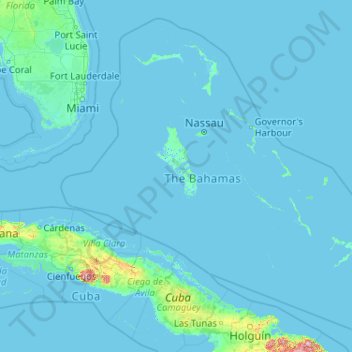
Name: Bahamas topographic map, elevation, terrain.
Location: Bahamas (20.70598 -80.70019 27.47346 -72.44775)
Average elevation: 9 m
Minimum elevation: -4 m
Maximum elevation: 1,111 m
Other topographic maps
Click on a map to view its topography, its elevation and its terrain.