
Quito topographic map
Interactive map
Click on the map to display elevation.
About this map
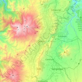
Name: Quito topographic map, elevation, terrain.
Location: Quito, Quito Canton, Pichincha, 170130, Ecuador (-0.38016 -78.67233 -0.06016 -78.35233)
Average elevation: 2,930 m
Minimum elevation: 1,897 m
Maximum elevation: 4,737 m
Quito (Spanish pronunciation: [ˈkito] (listen); Quechua: Kitu), formally San Francisco de Quito, is the capital and most populous city of Ecuador, with an estimated population of 2.8 million in its urban area. It is also the capital of the province of Pichincha. Quito is located in a valley on the eastern slopes of Pichincha, an active stratovolcano in the Andes, at an elevation of 2,850 m (9,350 ft), making it the second-highest capital city in the world.
Other topographic maps
Click on a map to view its topography, its elevation and its terrain.
La Floresta
Ecuador > Pichincha > Quito Canton > Nanegal
La Floresta, Nanegal, Quito Canton, Pichincha, Ecuador
Average elevation: 1,322 m
Iñaquito
Ecuador > Pichincha > Quito Canton
Iñaquito, Quito Canton, Pichincha, Ecuador
Average elevation: 2,806 m
Simon Bolivar
Ecuador > Pichincha > Quito Canton > Amaguaña
Simon Bolivar, Amaguaña, Quito Canton, Pichincha, 170807, Ecuador
Average elevation: 2,576 m
El Condado
Ecuador > Pichincha > Quito Canton
El Condado, Quito Canton, Pichincha, 170134, Ecuador
Average elevation: 2,822 m