
Jinan topographic map
Interactive map
Click on the map to display elevation.
About this map
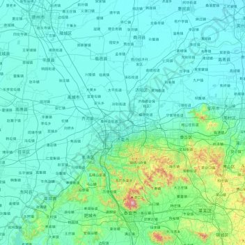
Name: Jinan topographic map, elevation, terrain.
Location: Jinan, Shandong, China (35.99207 116.21934 37.53815 117.97263)
Average elevation: 112 m
Minimum elevation: 6 m
Maximum elevation: 1,481 m
Due to the mountains to the south of the city, temperature inversions are common, occurring on about 200 days per year. The high precipitation for northern Chinese standards, in tandem with the topography (mountains surrounding the city on three sides), leads to particularly oppressive summer weather and the city being named as a candidate for the fourth "furnace", c.e. Three Furnaces. Extremes since 1951 have ranged from −19.7 °C (−3 °F) on 17 January 1953 to 42.5 °C (109 °F) on 24 July 1955.
Other topographic maps
Click on a map to view its topography, its elevation and its terrain.
东山街道
China > Shandong > Zhifu District
东山街道, Zhifu District, Yantai, Shandong, 264000, China
Average elevation: 37 m
Taishan District
Taishan District, Tai'an, Shandong, 271000, China
Average elevation: 286 m
Pingyi County
Pingyi County, Linyi City, Shandong, 273300, China
Average elevation: 225 m
Haiyang City
Haiyang City, Yantai City, Shandong, 265100, China
Average elevation: 65 m
Yishan
China > Shandong > Zoucheng City > Yishan
Yishan, Zoucheng City, Jining City, Shandong, China
Average elevation: 95 m
Yantai City
China > Shandong > Yantai City
Yantai City, Shandong, 264000, China
Average elevation: 39 m
Darwin River
China > Shandong > Jinan City
Darwin River, 钢城区, Gangcheng District, Jinan City, Shandong, 271103, China
Average elevation: 277 m