
Neekreen topographic map
Interactive map
Click on the map to display elevation.
About this map
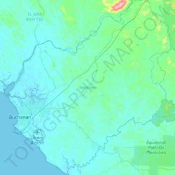
Name: Neekreen topographic map, elevation, terrain.
Location: Neekreen, Grand Bassa County, Liberia (5.78755 -10.06851 6.07082 -9.79437)
Average elevation: 32 m
Minimum elevation: -2 m
Maximum elevation: 344 m
Other topographic maps
Click on a map to view its topography, its elevation and its terrain.
Hilary
Liberia > Grand Bassa County > District # 2
Hilary, District # 2, Grand Bassa County, Liberia
Average elevation: 161 m
Buchanan
Liberia > Grand Bassa County > Commonwealth-B > Buchanan
Buchanan, Commonwealth-B, Grand Bassa County, 4000, Liberia
Average elevation: 3 m
Wredyu
Liberia > Grand Bassa County > Wredyu
Wredyu, District # 3, Grand Bassa County, Liberia
Average elevation: 133 m
Isreal Village
Liberia > Grand Bassa County > Isreal Village
Isreal Village, District # 3, Grand Bassa County, Liberia
Average elevation: 197 m
Commonwealth-B
Commonwealth-B, Grand Bassa County, Liberia
Average elevation: 4 m