
Mendos topographic map
Interactive map
Click on the map to display elevation.
About this map
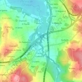
Name: Mendos topographic map, elevation, terrain.
Location: Mendos, Piadela, Betanzos, A Coruña, Galicia, 15389, Spain (43.24885 -8.26747 43.26885 -8.24747)
Average elevation: 74 m
Minimum elevation: 26 m
Maximum elevation: 145 m
Other topographic maps
Click on a map to view its topography, its elevation and its terrain.
Cervantes
Spain > Galicia > Os Ancares
These elevations are located in the nearby mountain ranges of A Trappe, Lóuzara, O Oribio, O Rañadoiro and O Piornal .
Average elevation: 992 m
Lugo
The town lies on a hill surrounded by the rivers Miño, Rato and Chanca. The difference in altitude between the city centre and the river banks is considerable: the former being at an altitude of 465 meters above sea level, whilst the Miño River Walk is at an altitude of only 364 metres (1,194 feet). The…
Average elevation: 489 m