
Würzburg topographic map
Interactive map
Click on the map to display elevation.
Würzburg
Würzburg covers an area of 87.6 square kilometres and lies at an altitude of around 177 metres.
About this map
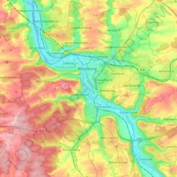
Name: Würzburg topographic map, elevation, terrain.
Location: Würzburg, Bavaria, Germany (49.71068 9.87163 49.84546 10.01443)
Average elevation: 270 m
Minimum elevation: 166 m
Maximum elevation: 385 m
Other topographic maps
Click on a map to view its topography, its elevation and its terrain.
Neuschwanstein Castle
Germany > Bavaria > Landkreis Ostallgäu > Hohenschwangau
The municipality of Schwangau lies at an elevation of 800 m (2,620 ft) at the southwest border of the German state of Bavaria. Its surroundings are characterised by the transition between the Alpine foothills in the south (toward the nearby Austrian border) and a hilly landscape in the north that appears flat…
Average elevation: 982 m
Ziegelhütte
Germany > Bavaria > Landkreis Wunsiedel im Fichtelgebirge > Marktredwitz
Average elevation: 563 m
Schönbühl
Germany > Bavaria > Landkreis Dingolfing-Landau > Dingolfing > Kronwieden
Average elevation: 375 m