Geolocate

Lansdowne topographic map

Interactive map

Click on the map to display elevation.

About this map

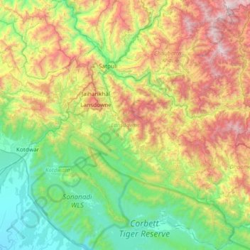
Name: Lansdowne topographic map, elevation, terrain.

Location: Lansdowne, Pauri Garhwal District, Uttarakhand, India (29.53945 78.50628 30.05245 79.00788)

Average elevation: 1,025 m

Minimum elevation: 253 m

Maximum elevation: 2,641 m

Other topographic maps

Click on a map to view its topography, its elevation and its terrain.

Kashipur

India > Uttarakhand > Kashipur

Average elevation: 233 m

Naini Lake

India > Uttarakhand > Nainital > Nainital

Average elevation: 2,057 m

Paharpani

India > Uttarakhand > Dhari > Mahtoligaon

Average elevation: 1,918 m

Joshimath

India > Uttarakhand > Joshimath Tehsil

Average elevation: 2,272 m

Barsu

India > Uttarakhand > Bhatwari

Average elevation: 2,322 m

Bhimtal

India > Uttarakhand > Nainital

Average elevation: 1,458 m

Dhamas

India > Uttarakhand > Almora

Average elevation: 1,387 m

Mukteshwar

India > Uttarakhand > Dhari

Average elevation: 1,982 m

Kumali

India > Uttarakhand > Narendra Nagar

Average elevation: 1,200 m

Chandrashila

India > Uttarakhand > Pokhari > Bhulkhana Chatti

Average elevation: 3,120 m

Nanna

India > Uttarakhand > Ranikhet > Batori > Nanna

Average elevation: 1,200 m

Thali

India > Uttarakhand > Dhari

Average elevation: 1,889 m

Bhaniyawala

India > Uttarakhand > Bhaniyawala

Average elevation: 510 m

Dunk

India > Uttarakhand > Dunk

Average elevation: 949 m

Bharatpur

India > Uttarakhand > Bharatpur

Average elevation: 1,447 m