
Biella topographic map
Interactive map
Click on the map to display elevation.
About this map
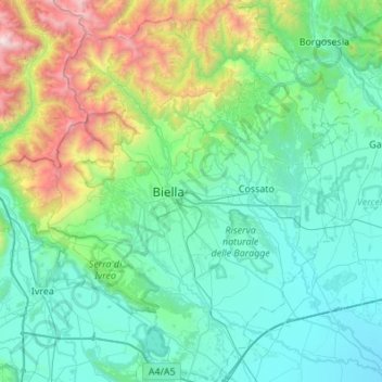
Name: Biella topographic map, elevation, terrain.
Location: Biella, Piedmont, Italy (45.37609 7.88146 45.75764 8.32791)
Average elevation: 668 m
Minimum elevation: 140 m
Maximum elevation: 3,061 m
Other topographic maps
Click on a map to view its topography, its elevation and its terrain.
San Rocco Castagnaretta
Italy > Piedmont > Cuneo > Cuneo > San Rocco Castagnaretta
Average elevation: 569 m