
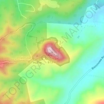
Table Top Mountain topographic map
Interactive map
Click on the map to display elevation.
About this map
Name: Table Top Mountain topographic map, elevation, terrain.
Location: Table Top Mountain, Toowoomba, Queensland, Australia (-27.58264 152.01430 -27.58254 152.01440)
Average elevation: 394 m
Minimum elevation: 271 m
Maximum elevation: 608 m
Queensland trails, hiking, mountain biking, running and outdoor activities
Other topographic maps
Click on a map to view its topography, its elevation and its terrain.