
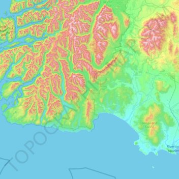
Tuatapere Te Waewae Community topographic map
Interactive map
Click on the map to display elevation.
About this map
Name: Tuatapere Te Waewae Community topographic map, elevation, terrain.
Average elevation: 324 m
Minimum elevation: 0 m
Maximum elevation: 1,735 m
Other topographic maps
Click on a map to view its topography, its elevation and its terrain.
Mount Tūtoko
New Zealand > Southland > Southland District > Fiordland Community
Average elevation: 1,892 m
Ohai
New Zealand > Southland > Southland District > Wallace Takitimu Community
Average elevation: 188 m
Forest Range
New Zealand > Southland > Southland District > Waihopai Toetoe Community
Average elevation: 373 m
Rakahouka
New Zealand > Southland > Southland District > Waihopai Toetoe Community
Average elevation: 38 m
Mount Elliot
New Zealand > Southland > Southland District > Fiordland Community
Average elevation: 1,110 m
Hollyford River
New Zealand > Southland > Southland District > Fiordland Community
Average elevation: 14 m
Lake Alabaster
New Zealand > Southland > Southland District > Fiordland Community
Average elevation: 605 m
Garston
New Zealand > Southland > Southland District > Northern Community > Garston
Average elevation: 373 m