
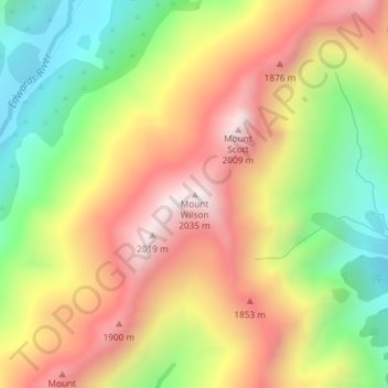
Mount Wilson topographic map
Interactive map
Click on the map to display elevation.
About this map
Name: Mount Wilson topographic map, elevation, terrain.
Location: Mount Wilson, Selwyn District, Canterbury, New Zealand (-42.93181 171.67845 -42.93171 171.67855)
Average elevation: 1,569 m
Minimum elevation: 1,111 m
Maximum elevation: 2,018 m
Other topographic maps
Click on a map to view its topography, its elevation and its terrain.
Lake Ōhau
New Zealand > Canterbury > Waitaki District
Wilding Pines (Pinus Cortorta, Pinus sylvestris) are problematic on the foreshore of Lake Ōhau. Pinus contorta grow “probably five to 10 times faster” in the Mackenzie Country (and Lake Ōhau) than in their native North America. They can establish themselves at altitudes of up to 2000 metres. Where they…
Average elevation: 904 m
Lake Tekapo
New Zealand > Canterbury > Mackenzie District
Lake Tekapo (Māori: Takapō) is the second-largest of three roughly parallel lakes running north–south along the northern edge of the Mackenzie Basin in the South Island of New Zealand (the others are Lake Pukaki and Lake Ōhau). It covers an area of 83 square kilometres (32 sq mi) and is at an altitude of…
Average elevation: 1,025 m
Kaikoura
The Hutton's shearwater (Puffinus huttoni) or Kaikōura tītī is an endangered seabird in the family Procellariidae. It is found in waters around Australia and New Zealand but it only breeds in the Seaward Kaikōura Range in New Zealand. It is the only seabird in the world that breeds in an alpine…
Average elevation: 530 m
Linwood-Central-Heathcote Community
New Zealand > Canterbury > Christchurch City
Average elevation: 55 m
Halswell-Hornby-Riccarton Community
New Zealand > Canterbury > Christchurch City
Average elevation: 49 m
Scarborough Beach
New Zealand > Canterbury > Linwood-Central-Heathcote Community
Average elevation: 45 m
Southern Alps / Kā Tiritiri o te Moana
New Zealand > Canterbury > Twizel
The Southern Alps / Kā Tiritiri o te Moana is a mountain range extending along much of the length of New Zealand's South Island, reaching its greatest elevations near the range's western side. The name "Southern Alps" generally refers to the entire range, although separate names are given to many of the…
Average elevation: 771 m
Le Bons Bay
New Zealand > Canterbury > Christchurch City > Banks Peninsula Community
Average elevation: 244 m