
Canterbury topographic map
Interactive map
Click on the map to display elevation.
About this map
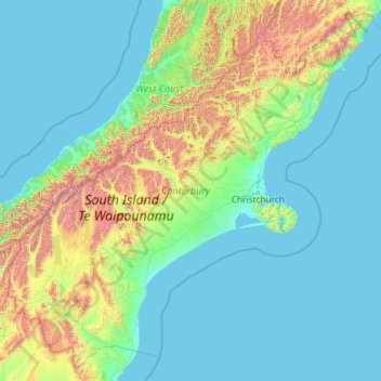
Name: Canterbury topographic map, elevation, terrain.
Location: Canterbury, New Zealand (-45.08093 169.54250 -41.90738 174.23901)
Average elevation: 357 m
Minimum elevation: -1 m
Maximum elevation: 3,454 m
Other topographic maps
Click on a map to view its topography, its elevation and its terrain.
Mount Lloyd
New Zealand > Canterbury > Mackenzie District
Mount Lloyd, Mackenzie District, Canterbury, New Zealand
Average elevation: 1,610 m
Ashburton District
Ashburton District, Canterbury, New Zealand
Average elevation: 661 m
Puketeraki
New Zealand > Canterbury > Selwyn District
Puketeraki, Selwyn District, Canterbury, New Zealand
Average elevation: 1,369 m
Methven
New Zealand > Canterbury > Ashburton District
Methven, Ashburton District, Canterbury, 7730, New Zealand
Average elevation: 322 m
Hydra Island
New Zealand > Canterbury > Selwyn District
Hydra Island, Selwyn District, Canterbury, New Zealand
Average elevation: 474 m
Mount Nathan
New Zealand > Canterbury > Mackenzie District
Mount Nathan, Mackenzie District, Canterbury, New Zealand
Average elevation: 2,344 m
Pearce
New Zealand > Canterbury > Christchurch City > Banks Peninsula Community
Pearce, Banks Peninsula Community, Christchurch City, Canterbury, 7581, New Zealand
Average elevation: 485 m
Kairaki
New Zealand > Canterbury > Waimakariri District > The Pines Beach
Kairaki, The Pines Beach, Waimakariri District, Canterbury, 7630, New Zealand
Average elevation: 1 m
Mount Alford
New Zealand > Canterbury > Ashburton District
Mount Alford, Ashburton District, Canterbury, New Zealand
Average elevation: 806 m
Twizel
New Zealand > Canterbury > Mackenzie District
Twizel, Mackenzie District, Canterbury, 7901, New Zealand
Average elevation: 472 m
Lake Tekapo
New Zealand > Canterbury > Mackenzie District
Lake Tekapo, Mackenzie District, Canterbury, New Zealand
Average elevation: 1,025 m
Duntroon
New Zealand > Canterbury > Waitaki District
Duntroon, Waitaki District, Canterbury, New Zealand
Average elevation: 150 m
Selwyn
New Zealand > Canterbury > Selwyn District
Selwyn, Selwyn District, Canterbury, 7682, New Zealand
Average elevation: 70 m
Mount David
New Zealand > Canterbury > Waitaki District
Mount David, Waitaki District, Canterbury, New Zealand
Average elevation: 995 m
Otematata
New Zealand > Canterbury > Waitaki District
Otematata, Waitaki District, Canterbury, New Zealand
Average elevation: 343 m
Clarkville
New Zealand > Canterbury > Waimakariri District > Kaiapoi
Clarkville, Kaiapoi, Waimakariri District, Canterbury, 7692, New Zealand
Average elevation: 8 m
Mount Alexander
New Zealand > Canterbury > Kaikōura
Mount Alexander, Kaikōura, Canterbury, 7371, New Zealand
Average elevation: 737 m
Constitution Hill
New Zealand > Canterbury > Kaikōura
Constitution Hill, Kaikōura, Canterbury, New Zealand
Average elevation: 1,566 m
Rolleston
New Zealand > Canterbury > Selwyn District
Rolleston, Selwyn District, Canterbury, 7643, New Zealand
Average elevation: 54 m
Greendale
New Zealand > Canterbury > Selwyn District
Greendale, Selwyn District, Canterbury, 7671, New Zealand
Average elevation: 132 m
Summerhill
New Zealand > Canterbury > Waimakariri District
Summerhill, Waimakariri District, Canterbury, 7473, New Zealand
Average elevation: 178 m
Christchurch
New Zealand > Canterbury > Christchurch City
Christchurch, Christchurch City, Canterbury, New Zealand
Average elevation: 41 m
Lincoln
New Zealand > Canterbury > Selwyn District
Lincoln, Selwyn District, Canterbury, 7608, New Zealand
Average elevation: 15 m
Kurow
New Zealand > Canterbury > Waitaki District
Kurow, Waitaki District, Canterbury, 9435, New Zealand
Average elevation: 274 m
Waitaki District
Waitaki District, Canterbury, New Zealand
Average elevation: 630 m
Linwood-Central-Heathcote Community
New Zealand > Canterbury > Christchurch City
Linwood-Central-Heathcote Community, Christchurch City, Canterbury, New Zealand
Average elevation: 55 m
Kaiapoi
New Zealand > Canterbury > Waimakariri District
Kaiapoi, Waimakariri District, Canterbury, 7630, New Zealand
Average elevation: 5 m
Amberley
New Zealand > Canterbury > Hurunui District
Amberley, Hurunui District, Canterbury, 7441, New Zealand
Average elevation: 55 m
Darfield
New Zealand > Canterbury > Selwyn District
Darfield, Selwyn District, Canterbury, 7510, New Zealand
Average elevation: 202 m
Halswell-Hornby-Riccarton Community
New Zealand > Canterbury > Christchurch City
Halswell-Hornby-Riccarton Community, Christchurch City, Canterbury, New Zealand
Average elevation: 49 m
Lyttelton
New Zealand > Canterbury > Christchurch City > Banks Peninsula Community > Lyttelton
Lyttelton, Banks Peninsula Community, Christchurch City, Canterbury, 8082, New Zealand
Average elevation: 99 m
Hanmer Springs
New Zealand > Canterbury > Hurunui District > Hanmer Springs
Hanmer Springs, Hurunui District, Canterbury, 7334, New Zealand
Average elevation: 397 m
Akaroa
New Zealand > Canterbury > Christchurch City > Banks Peninsula Community
Akaroa, Banks Peninsula Community, Christchurch City, Canterbury, New Zealand
Average elevation: 152 m
Banks Peninsula
New Zealand > Canterbury > Christchurch City > Banks Peninsula Community > Pigeon Bay
Banks Peninsula, Pigeon Bay, Banks Peninsula Community, Christchurch City, Canterbury, 7581, New Zealand
Average elevation: 277 m
Christchurch
New Zealand > Canterbury > Christchurch
Christchurch, Linwood-Central-Heathcote Community, Christchurch City, Canterbury, 8011, New Zealand
Average elevation: 54 m
Le Bons Bay
New Zealand > Canterbury > Banks Peninsula Community > Le Bons Bay
Le Bons Bay, Banks Peninsula Community, Christchurch City, Canterbury, 7583, New Zealand
Average elevation: 244 m
Wheatstone
New Zealand > Canterbury > Ashburton District
Wheatstone, Ashburton District, Canterbury, New Zealand
Average elevation: 47 m
Mole Hill
New Zealand > Canterbury > Kaikōura District
Mole Hill, Kaikōura District, Canterbury, New Zealand
Average elevation: 228 m
Timaru
New Zealand > Canterbury > Timaru District
Timaru, Timaru District, Canterbury, 7910, New Zealand
Average elevation: 16 m
Christchurch City
Christchurch City, Canterbury, New Zealand
Average elevation: 74 m
Hunter
Hunter, Waimate District, Canterbury, New Zealand
Average elevation: 118 m
Bonds Peak
Bonds Peak, Ashburton District, Canterbury, New Zealand
Average elevation: 1,754 m
Twyford Reserve
New Zealand > Canterbury > Christchurch
Twyford Reserve, Bishopdale, Christchurch, Christchurch City, Canterbury, New Zealand
Average elevation: 21 m
Grey River
Grey River, Waimakariri District, Canterbury, New Zealand
Average elevation: 259 m
Mount Richmond
Mount Richmond, Mackenzie District, Canterbury, New Zealand
Average elevation: 2,071 m
Ashburton River
Ashburton River, Ashburton District, Canterbury, 7700, New Zealand
Average elevation: 60 m
Arthur's Pass
New Zealand > Canterbury > Selwyn District
Arthur's Pass, Selwyn District, Canterbury, 7875, New Zealand
Average elevation: 1,204 m
Southern Alps / Kā Tiritiri o te Moana
New Zealand > Canterbury > Twizel
Southern Alps / Kā Tiritiri o te Moana, De Havilland Drive, Twizel, Mackenzie District, Canterbury, 5744, New Zealand
Average elevation: 771 m
Mount Clear
Mount Clear, Hurunui District, Canterbury, New Zealand
Average elevation: 1,087 m