
Lehigh County topographic map
Interactive map
Click on the map to display elevation.
Lehigh County
Lehigh County borders two Appalachian mountain ridges. To the north, the county borders Blue Mountain, which has an altitude of 1,300 to 1,604 feet (396 to 489 m). To the south, it is bordered by South Mountain, which has an altitude of 700 to 1,100 feet (210 to 340 m) and cuts through the southern portions of both Lehigh and Northampton counties. The Lehigh County's highest point is near Germansville at Bake Oven Knob, a mass of Tuscarora conglomeratic rocks that rise about 100 feet (30 m) above the main Blue Mountain ridge in northwestern Heidelberg Township.
About this map
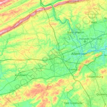
Name: Lehigh County topographic map, elevation, terrain.
Location: Lehigh County, Pennsylvania, United States (40.41848 -75.89147 40.78669 -75.33305)
Average elevation: 186 m
Minimum elevation: 64 m
Maximum elevation: 509 m
Other topographic maps
Click on a map to view its topography, its elevation and its terrain.
Sunshine Hill
United States > Pennsylvania > Fayette County > Nicholson Township
Average elevation: 294 m
Parkland Heights
United States > Pennsylvania > Bucks County > Middletown Township
Average elevation: 45 m
Oakville
United States > Pennsylvania > Cumberland County > North Newton Township
Average elevation: 180 m
Hubbard Mountain
United States > Pennsylvania > Lackawanna County > Scott Township
Average elevation: 503 m
Mill Run
United States > Pennsylvania > Blair County > Altoona > Allegheny Furnace
Average elevation: 349 m
Willow Grove
United States > Pennsylvania > Montgomery County > Upper Moreland Township
Average elevation: 91 m
Martin's Creek
United States > Pennsylvania > Northampton County > Lower Mount Bethel Township > Martins Creek
Average elevation: 152 m
Rehrersburg
United States > Pennsylvania > Berks County > Tulpehocken Township
Average elevation: 165 m
Millers
United States > Pennsylvania > Northampton County > Plainfield Township
Average elevation: 200 m
Williamstown
United States > Pennsylvania > Lehigh County > Washington Township
Average elevation: 178 m
Rocky Valley
United States > Pennsylvania > Bucks County > Springfield Township
Average elevation: 190 m
Pendle Hill
United States > Pennsylvania > Delaware County > Nether Providence Township
Average elevation: 61 m
Freysville
United States > Pennsylvania > York County > Windsor Township > Freysville
Average elevation: 233 m
Chadds Ford
United States > Pennsylvania > Delaware County > Chadds Ford Township > Chadds Ford
Average elevation: 86 m
Bob Case Park
United States > Pennsylvania > Montgomery County > Upper Merion Township > King of Prussia > Sweet Briar
Average elevation: 45 m
Spring Ridge
United States > Pennsylvania > Berks County > Spring Township > Spring Ridge
Average elevation: 98 m
Philadelphia
United States > Pennsylvania > Philadelphia County > Philadelphia
Average elevation: 35 m
Eyer
United States > Pennsylvania > Huntingdon County > Warriors Mark Township > Eyer
Average elevation: 380 m
Fairfield Heights
United States > Pennsylvania > Indiana County > Burrell Township
Average elevation: 396 m
Audubon
United States > Pennsylvania > Montgomery County > Lower Providence Township > Audubon
Average elevation: 55 m
Mill Run
United States > Pennsylvania > Fayette County > Springfield Township
Average elevation: 482 m
Brittains Corner
United States > Pennsylvania > Schuylkill Township > Valley Forge > Brittains Corner
Average elevation: 81 m
Plain Grove
United States > Pennsylvania > Plain Grove Township > Plain Grove
Average elevation: 360 m
Glenrose
United States > Pennsylvania > Chester County > East Fallowfield Township > Glenrose
Average elevation: 154 m
Gooseberry Hill
United States > Pennsylvania > Sullivan County > Hillsgrove Township
Average elevation: 446 m