
Bucks County topographic map
Interactive map
Click on the map to display elevation.
Bucks County
According to the Trewartha climate classification system, the Piedmont (United States) section of Bucks County, which is located roughly northwest of U.S. Route 1, has a Temperate Continental Climate with hot and slightly humid summers, cold winters and year-around precipitation (Dcao). Dcao climates are characterized by at least one month having an average mean temperature ≤ 32.0 °F (0 °C), four to seven months with an average mean temperature ≥ 50.0 °F (10 °C), at least one month with an average mean temperature ≥ 72.0 °F (22 °C) and no significant precipitation difference between seasons. According to the Köppen climate classification system, the climate is a hot-summer, wet all year, humid continental climate (Dfa). During the summer months in the Piedmont, episodes of extreme heat and humidity can occur with heat index values > 102 °F (39 °C). The average wettest month is July which corresponds with the annual peak in thunderstorm activity. During the winter months, episodes of extreme cold and wind can occur with wind chill values < −16 °F (−27 °C). The plant hardiness zone at Haycock Mountain, elevation 968 ft (295 m), is 6b with an average annual extreme minimum air temperature of −4.6 °F (−20 °C). The average seasonal (Nov-Apr) snowfall total is between 26 and 36 inches (66 and 91 cm) depending on elevation and distance from the Atlantic Ocean. The average snowiest month is February which correlates with the annual peak in nor'easter activity. Some areas of the Piedmont farther south and along the river below New Hope are in hardiness zone 7a, as is the Atlantic Coastal Plain region of Bucks.
About this map
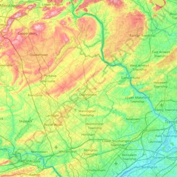
Name: Bucks County topographic map, elevation, terrain.
Location: Bucks County, Pennsylvania, United States (40.04980 -75.48393 40.60872 -74.72111)
Average elevation: 98 m
Minimum elevation: -2 m
Maximum elevation: 312 m
Other topographic maps
Click on a map to view its topography, its elevation and its terrain.
Sunshine Hill
United States > Pennsylvania > Fayette County > Nicholson Township
Average elevation: 294 m
Parkland Heights
United States > Pennsylvania > Bucks County > Middletown Township
Average elevation: 45 m
Oakville
United States > Pennsylvania > Cumberland County > North Newton Township
Average elevation: 180 m
Hubbard Mountain
United States > Pennsylvania > Lackawanna County > Scott Township
Average elevation: 503 m
Mill Run
United States > Pennsylvania > Blair County > Altoona > Allegheny Furnace
Average elevation: 349 m
Willow Grove
United States > Pennsylvania > Montgomery County > Upper Moreland Township
Average elevation: 91 m
Martin's Creek
United States > Pennsylvania > Northampton County > Lower Mount Bethel Township > Martins Creek
Average elevation: 152 m
Rehrersburg
United States > Pennsylvania > Berks County > Tulpehocken Township
Average elevation: 165 m
Millers
United States > Pennsylvania > Northampton County > Plainfield Township
Average elevation: 200 m
Williamstown
United States > Pennsylvania > Lehigh County > Washington Township
Average elevation: 178 m
Rocky Valley
United States > Pennsylvania > Bucks County > Springfield Township
Average elevation: 190 m
Pendle Hill
United States > Pennsylvania > Delaware County > Nether Providence Township
Average elevation: 61 m
Freysville
United States > Pennsylvania > York County > Windsor Township > Freysville
Average elevation: 233 m
Chadds Ford
United States > Pennsylvania > Delaware County > Chadds Ford Township > Chadds Ford
Average elevation: 86 m
Bob Case Park
United States > Pennsylvania > Montgomery County > Upper Merion Township > King of Prussia > Sweet Briar
Average elevation: 45 m
Spring Ridge
United States > Pennsylvania > Berks County > Spring Township > Spring Ridge
Average elevation: 98 m
Philadelphia
United States > Pennsylvania > Philadelphia County > Philadelphia
Average elevation: 35 m
Eyer
United States > Pennsylvania > Huntingdon County > Warriors Mark Township > Eyer
Average elevation: 380 m
Fairfield Heights
United States > Pennsylvania > Indiana County > Burrell Township
Average elevation: 396 m
Audubon
United States > Pennsylvania > Montgomery County > Lower Providence Township > Audubon
Average elevation: 55 m
Mill Run
United States > Pennsylvania > Fayette County > Springfield Township
Average elevation: 482 m
Brittains Corner
United States > Pennsylvania > Schuylkill Township > Valley Forge > Brittains Corner
Average elevation: 81 m
Plain Grove
United States > Pennsylvania > Plain Grove Township > Plain Grove
Average elevation: 360 m
Glenrose
United States > Pennsylvania > Chester County > East Fallowfield Township > Glenrose
Average elevation: 154 m
Gooseberry Hill
United States > Pennsylvania > Sullivan County > Hillsgrove Township
Average elevation: 446 m