
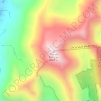
Mount Morgan topographic map
Interactive map
Click on the map to display elevation.
About this map
Name: Mount Morgan topographic map, elevation, terrain.
Average elevation: 3,689 m
Minimum elevation: 3,185 m
Maximum elevation: 4,166 m
Other topographic maps
Click on a map to view its topography, its elevation and its terrain.
Upland
United States of America > California > Upland
Upland is a city in San Bernardino County, California, United States. The municipality is located at an elevation of 1,242 feet (379 m). As of the 2010 census, the city had a population of 73,732, up from 68,393 at the 2000 census. It was incorporated on May 15, 1906, after previously being named North…
Average elevation: 457 m
Tranquillity
United States of America > California > Tranquillity
Tranquillity is a census-designated place (CDP) in Fresno County, California, United States. The population was 799 at the 2010 census, down from 813 at the 2000 census. Tranquillity High School is the only high school in Tranquillity. Tranquillity is located 10 miles (16 km) southeast of Mendota, at an…
Average elevation: 49 m
Hidden Valley Lake
United States of America > California > Hidden Valley Lake
Average elevation: 389 m
Mammoth Lakes
United States of America > California > Mammoth Lakes
Mammoth Lakes is a town in Mono County, California, the county's only incorporated community. It is located immediately to the east of Mammoth Mountain, at an elevation of 7,880 feet (2,400 m). As of the 2010 United States Census, the population was 8,234, reflecting a 16% increase from the 2000 Census.
Average elevation: 2,687 m
San Rafael
United States of America > California > San Rafael
San Rafael has a wide diversity of natural habitats from forests at the higher elevations to marshland and estuarine settings. Its marshes are home to the endangered species Salt Marsh Harvest Mouse. There are also riparian areas including the San Rafael Creek and Miller Creek corridors.
Average elevation: 78 m
Lancaster
United States of America > California > Lancaster
According to the United States Census Bureau, the city has a total area of 94.5 square miles (245 km2), of which 94.3 square miles (244 km2) is land and 0.3 square miles (0.78 km2) (0.29%) is water. Lancaster's elevation is 2,350 feet (720 m) above sea level on a high, flat valley surrounded by pristine…
Average elevation: 787 m
Chino Hills
United States of America > California > Chino Hills
Due to its topography of rolling hills, Chino Hills was primarily rural prior to the mid-1970s; most land was utilized for equestrian purposes and for dairies, except for the multi-use purposes of the State of California, promoting jobs for the community through day labor from the Chino Institute for Men on…
Average elevation: 255 m
Mettler
United States of America > California > Mettler
Mettler, which is 25 miles (40 km) south of Bakersfield, is at 35°03′50″N 118°58′12″W / 35.06389°N 118.97000°W / 35.06389; -118.97000. The locality has an area of 0.2 square miles (0.52 km2) and an elevation of 541 feet (165 m).
Average elevation: 164 m
Clearlake
United States of America > California > Clearlake
Clearlake is a city in Lake County, California, United States. Clearlake is 4.5 miles (7.2 km) north-northwest of Lower Lake, at an elevation of 1417 feet (432 m). As of the 2010 census, the city had a total population of 15,250, up from 13,142 in 2000. It takes its name from Clear Lake.
Average elevation: 474 m