
Worthing topographic map
Interactive map
Click on the map to display elevation.
About this map
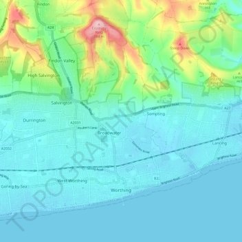
Name: Worthing topographic map, elevation, terrain.
Location: Worthing, West Sussex, England, United Kingdom (50.80174 -0.44656 50.86326 -0.33026)
Average elevation: 35 m
Minimum elevation: -3 m
Maximum elevation: 183 m
Other topographic maps
Click on a map to view its topography, its elevation and its terrain.
Ferring Rife
United Kingdom > England > West Sussex > Worthing > Goring-by-Sea
Average elevation: 14 m
Blackdown
United Kingdom > England > West Sussex > Chichester
Because of its elevation, from 1796 to 1816 Blackdown hosted a station in the shutter telegraph chain which quickly linked the Admiralty in London to its naval ships in Portsmouth.
Average elevation: 165 m