Geolocate

Mount Razorback topographic map

Interactive map

Click on the map to display elevation.

About this map

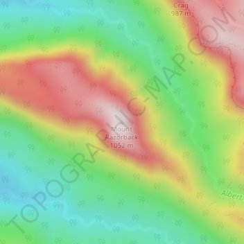
Name: Mount Razorback topographic map, elevation, terrain.

Location: Mount Razorback, Gold Coast, Queensland, Australia (-28.25644 153.12717 -28.25634 153.12727)

Average elevation: 643 m

Minimum elevation: 345 m

Maximum elevation: 1,032 m

Queensland trails, hiking, mountain biking, running and outdoor activities

Other topographic maps

Click on a map to view its topography, its elevation and its terrain.

Reedy Creek

Australia > Queensland > Gold Coast

Average elevation: 16 m

Coomera River

Australia > Queensland > Gold Coast

Average elevation: 563 m

Kingsholme

Australia > Queensland > Gold Coast

Average elevation: 127 m

Araucaria Forest

Australia > Queensland > Gold Coast

Average elevation: 6 m

Reedy Creek

Australia > Queensland > Gold Coast

Average elevation: 25 m

Nerang River

Australia > Queensland > Gold Coast

Average elevation: 492 m

Reedy Creek

Australia > Queensland > Gold Coast

Average elevation: 40 m