
Ventnor topographic map
Interactive map
Click on the map to display elevation.
Ventnor
Ventnor's landmarks arise from its natural environment, its Victorian heritage, and its tourist appeal past and present. Although modest in altitude at 241 metres (791 ft), the chalk St Boniface Down is 1⁄2 mile (0.80 km) north of the town. The downs have a thick layer of acid flint gravels, with dry heathland vegetation. The town's small beach of reddish chert sand and pebbles of flint and chert, with Ventnor Haven to the east and the prominent Spyglass Inn at its western end, will be familiar to many visitors. It is backed by an esplanade, which was created in 1848, now fronted by pubs, cafes, shops and restaurants. The gnomon on the esplanade was presented to the town by Sir Thomas Brisbane in 1851. At its eastern end is Ventnor's pumping station, a £14 million project completed in 2002 as part of 'Shifting Sands', a joint initiative between English Heritage and the Commission for Architecture and the Built Environment. It is disguised as a bandstand and viewing platform.
About this map
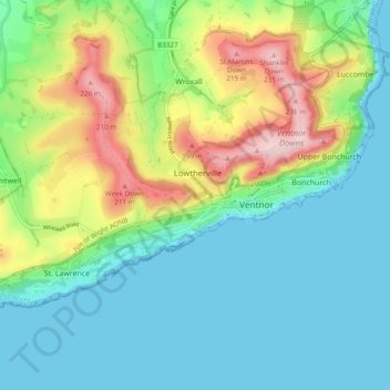
Name: Ventnor topographic map, elevation, terrain.
Location: Ventnor, Isle of Wight, England, United Kingdom (50.57899 -1.26981 50.61395 -1.17426)
Average elevation: 69 m
Minimum elevation: 0 m
Maximum elevation: 241 m
Other topographic maps
Click on a map to view its topography, its elevation and its terrain.