Mercer County topographic map
Click on the map to display elevation.
About this map
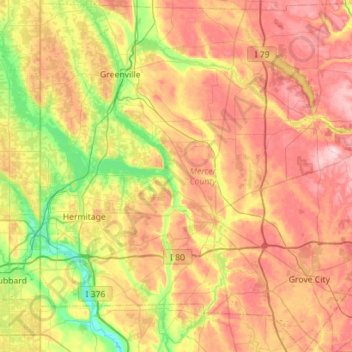
Name: Mercer County topographic map, elevation, terrain.
Location: Mercer County, Pennsylvania, United States (41.06968 -80.51926 41.49222 -79.99838)
Average elevation: 362 m
Minimum elevation: 242 m
Maximum elevation: 498 m
Other topographic maps
Click on a map to view its topography, its elevation and its terrain.
Dingmans Ferry
United States > Pennsylvania > Pike County > Delaware Township
Average elevation: 192 m

Muncy Valley
United States > Pennsylvania > Sullivan County > Davidson Township
Average elevation: 378 m
East Texas
United States > Pennsylvania > Lehigh County > Lower Macungie Township
Average elevation: 126 m


Chester Springs
United States > Pennsylvania > Chester County > West Pikeland Township
Average elevation: 112 m

Brackney
United States > Pennsylvania > Susquehanna County > Silver Lake Township
Average elevation: 491 m
Lords Valley
United States > Pennsylvania > Pike County > Blooming Grove Township
Average elevation: 412 m



Valley Forge
United States > Pennsylvania > Chester County > Schuylkill Township
Average elevation: 78 m





Waterville
United States > Pennsylvania > Lycoming County > Cummings Township
Average elevation: 388 m
Penn Valley
United States > Pennsylvania > Montgomery County > Lower Merion Township > Ardmore
Average elevation: 89 m


Wapwallopen
United States > Pennsylvania > Luzerne County > Conyngham Township
Average elevation: 223 m


White Church
United States > Pennsylvania > Westmoreland County > North Huntingdon Township
Average elevation: 331 m

Mount Nebo Park
United States > Pennsylvania > Monroe County > East Stroudsburg > Twin Falls
Average elevation: 185 m

Pricetown
United States > Pennsylvania > Berks County > Ruscombmanor Township
Average elevation: 239 m
Cornwells Heights
United States > Pennsylvania > Bucks County > Bensalem Township
Average elevation: 16 m
Cowden
United States > Pennsylvania > Washington County > Cecil Township > Cecil
Average elevation: 346 m
Keown Station
United States > Pennsylvania > Allegheny County > Ross Township
Average elevation: 344 m


Chapel
United States > Pennsylvania > Berks County > Hereford Township > Hereford
Average elevation: 139 m

Stony Creek Mills
United States > Pennsylvania > Berks County > Lower Alsace Township > Pennside
Average elevation: 192 m

Riddlesburg
United States > Pennsylvania > Bedford County > Broad Top Township
Average elevation: 373 m

New Enterprise
United States > Pennsylvania > Bedford County > South Woodbury Township
Average elevation: 397 m

Loysburg
United States > Pennsylvania > Bedford County > South Woodbury Township
Average elevation: 424 m
Blue Knob
United States > Pennsylvania > Bedford County > Pavia Township
Blue Knob (elevation 3,146 feet (959 m)) is a summit in the eastern United States with a broad dome that is the northernmost 3,000-footer in the Allegheny Mountains. It is the highest point in Bedford County, Pennsylvania.
Average elevation: 792 m

Sinnemahoning
United States > Pennsylvania > Cameron County > Gibson Township
Average elevation: 406 m
Saint Benedict
United States > Pennsylvania > Cambria County > West Carroll Township
Average elevation: 582 m
English Center
United States > Pennsylvania > Lycoming County > Pine Township
Average elevation: 444 m

Tyrrel Farm Corners
United States > Pennsylvania > Venango County > Allegheny Township
Average elevation: 478 m

Rockville
United States > Pennsylvania > Dauphin County > Susquehanna Township
Average elevation: 141 m
Fort Hunter
United States > Pennsylvania > Dauphin County > Middle Paxton Township
Average elevation: 149 m

Carsonville
United States > Pennsylvania > Dauphin County > Jefferson Township
Average elevation: 270 m

Green Village
United States > Pennsylvania > Franklin County > Greene Township
Average elevation: 207 m
Normalville
United States > Pennsylvania > Fayette County > Springfield Township
Average elevation: 486 m
Arnold City
United States > Pennsylvania > Fayette County > Washington Township
Average elevation: 303 m
Three Tuns
United States > Pennsylvania > Montgomery County > Upper Dublin Township > Maple Glen
Average elevation: 101 m
Hidden Valley
United States > Pennsylvania > Montgomery County > Upper Merion Township
Average elevation: 47 m
Worcester
United States > Pennsylvania > Montgomery County > Worcester Township
Average elevation: 93 m
Strafford
United States > Pennsylvania > Chester County > Tredyffrin Township
Average elevation: 133 m
West Pittsburg
United States > Pennsylvania > Lawrence County > Taylor Township
Average elevation: 279 m
Pennsylvania Furnace
United States > Pennsylvania > Huntingdon County > Franklin Township
Average elevation: 363 m
Dilltown
United States > Pennsylvania > Indiana County > East Wheatfield Township
Average elevation: 474 m
Robinson
United States > Pennsylvania > Indiana County > West Wheatfield Township
Average elevation: 397 m
Hazelton Mills
United States > Pennsylvania > McKean County > Bradford Township
Average elevation: 598 m
Fogelsville
United States > Pennsylvania > Lehigh County > Upper Macungie Township
Average elevation: 155 m
Mount Bethel
United States > Pennsylvania > Northampton County > Upper Mount Bethel Township
Average elevation: 156 m

Riddlewood
United States > Pennsylvania > Delaware County > Middletown Township
Average elevation: 79 m

Rosemount
United States > Pennsylvania > York County > Spring Garden Township
Average elevation: 167 m