
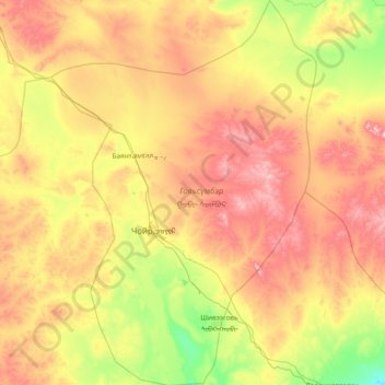
Govisumber topographic map
Interactive map
Click on the map to display elevation.
About this map
Name: Govisumber topographic map, elevation, terrain.
Location: Govisumber, Mongolia (45.93452 107.95679 46.98035 109.00391)
Average elevation: 1,309 m
Minimum elevation: 1,055 m
Maximum elevation: 1,720 m
Other topographic maps
Click on a map to view its topography, its elevation and its terrain.
Burkhan Khaldun
Mongolia > Khentii > Omnodelger
Burkhan Khaldun means the "God Mountain" and is also called Khentii Khan (The King of the Khentii Mountain range). It is one of the Khentii Mountains in the Khentii Province of northeastern Mongolia. It is the highest mountain of the region, rising to an elevation of 2,362 metres (7,749 ft), and is…
Average elevation: 2,113 m