
Dalhousie topographic map
Interactive map
Click on the map to display elevation.
About this map
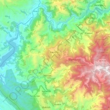
Name: Dalhousie topographic map, elevation, terrain.
Location: Dalhousie, Chamba, Himachal Pradesh, India (32.47001 75.83044 32.61554 76.02363)
Average elevation: 1,247 m
Minimum elevation: 490 m
Maximum elevation: 2,752 m
Other topographic maps
Click on a map to view its topography, its elevation and its terrain.
Dharamshala
India > Himachal Pradesh > Dharamshala
The town is located in the Kangra Valley, in the shadow of the Dhauladhar range of the Himalayas at an altitude of 1,457 metres (4,780 ft). References to Dharamshala and its surrounding areas are found in ancient Hindu scriptures such as Rig Veda and Mahabharata. The region was under Mughal influence before it…
Average elevation: 1,781 m