
Crystal Creek topographic map
Interactive map
Click on the map to display elevation.
About this map
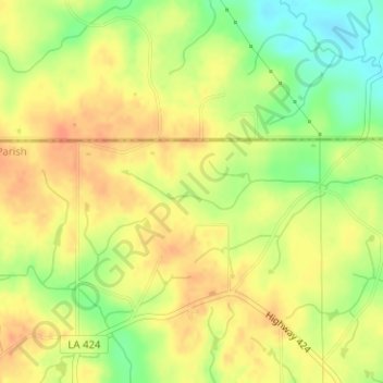
Name: Crystal Creek topographic map, elevation, terrain.
Location: Crystal Creek, Washington Parish, Louisiana, United States (30.99641 -90.02473 30.99891 -90.01460)
Average elevation: 94 m
Minimum elevation: 68 m
Maximum elevation: 109 m
Other topographic maps
Click on a map to view its topography, its elevation and its terrain.
Ponchatoula
United States > Louisiana > Tangipahoa Parish
Ponchatoula is located at 30°26′21″N 90°26′33″W / 30.43917°N 90.44250°W / 30.43917; -90.44250 (30.439162, -90.442507) and has an elevation of 26 feet (7.9 m). According to the United States Census Bureau, the city has a total area of 4.2 square miles (11 km2), all land.
Average elevation: 9 m
Houma
United States > Louisiana > Terrebonne Parish
Houma is located at 29°35′15″N 90°42′58″W / 29.58750°N 90.71611°W / 29.58750; -90.71611 (29.587614, -90.716108) and has an elevation of 10 feet (3.0 m) above sea level. According to the United States Census Bureau, the city has a total area of 14.2 square miles (37 km2), of which 14.0…
Average elevation: 3 m
Alexandria
United States > Louisiana > Rapides Parish > Alexandria
Alexandria is located at 31°17′34″N 92°27′33″W / 31.29278°N 92.45917°W / 31.29278; -92.45917 and has an elevation of 75 feet (22.9 m).
Average elevation: 25 m
Black Pearl
United States > Louisiana > Orleans Parish > New Orleans > Black Pearl
Black Pearl is located at 29°56′11″N 90°08′02″W / 29.93639°N 90.13389°W / 29.93639; -90.13389 and has an elevation of 8 feet (2.4 m). According to the United States Census Bureau, the district has a total area of 0.49 square miles (1.3 km2). 0.26 square miles (0.67 km2) of which is land…
Average elevation: 3 m
Mandeville
United States > Louisiana > Mandeville
Mandeville is located at 30°22′9″N 90°4′41″W / 30.36917°N 90.07806°W / 30.36917; -90.07806 (30.369282, -90.078006) and has an elevation of 7 feet (2.1 m).
Average elevation: 6 m
Gretna
United States > Louisiana > Gretna
Gretna is located at 29°54′59″N 90°3′15″W / 29.91639°N 90.05417°W / 29.91639; -90.05417 (29.916459, -90.054260) and has an elevation of 0 feet (0 m) behind the levee along the Mississippi River.
Average elevation: 2 m