
Fayette County topographic map
Interactive map
Click on the map to display elevation.
About this map
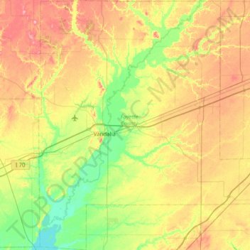
Name: Fayette County topographic map, elevation, terrain.
Location: Fayette County, Illinois, United States (38.73609 -89.25684 39.21653 -88.69463)
Average elevation: 171 m
Minimum elevation: 131 m
Maximum elevation: 230 m
Other topographic maps
Click on a map to view its topography, its elevation and its terrain.
Elmhurst
United States > Illinois > DuPage County
Due to local topography, the town has had a tendency to flood in the past after large rainfalls; the city is currently undertaking a large effort to mitigate future flooding.
Average elevation: 210 m
Lake Zurich Highlands
United States > Illinois > Lake Zurich > Lake Zurich Highlands
Average elevation: 261 m