
Dutchess County topographic map
Interactive map
Click on the map to display elevation.
About this map
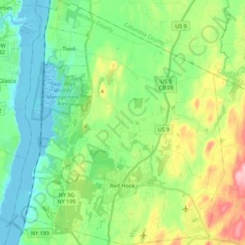
Name: Dutchess County topographic map, elevation, terrain.
Location: Town of Red Hook, Dutchess County, New York, United States (41.96737 -73.94464 42.08091 -73.81194)
Average elevation: 62 m
Minimum elevation: -6 m
Maximum elevation: 210 m
Other topographic maps
Click on a map to view its topography, its elevation and its terrain.
Chester Heights
United States > New York > Westchester County > City of New Rochelle
Average elevation: 36 m
Dutch Settlement
United States > New York > Oswego County > Town of West Monroe
Average elevation: 148 m
Black Creek Village
United States > New York > Niagara County > City of Niagara Falls
Average elevation: 176 m
West Point
United States > New York > Suffolk County > Hampton Bays > Town of Southampton > Rampasture
Average elevation: 3 m
Lower Bridal Veil Falls
United States > New York > Greene County > Town of Hunter
Average elevation: 620 m
Bonny Hill
United States > New York > Steuben County > Town of Thurston > Bonny Hill
Average elevation: 488 m
Black Mountain
United States > New York > Washington County
Black Mountain is a mountain located in Washington County, New York, of which its peak is the highest point. Isolated from the rest of the Adirondack Mountains by Lake George, Black Mtn. has the seventh highest topographic prominence of all the mountains in New York. Black Mountain also has the highest…
Average elevation: 487 m
Malone Junction
United States > New York > Franklin County > Malone > Malone Junction
Average elevation: 233 m
Saint John's Park
United States > New York > New York
It took over 20 years for all the lots to be sold and developed, partly because of the swampy topography, but also because the church was only offering 99-year leases, not outright ownership of the lots, with covenants which limited the heights of residences and the materials they were built with. During this…
Average elevation: 11 m
Town of Keene
United States > New York > Essex County
Saddleback Mountain is a mountain in the Great Range of the Adirondacks in the U. S. state of New York. It is the 17th-highest of the Adirondack High Peaks, with an elevation of 4,515 feet (1,376 m). It is located in Adirondack Park in the town of Keene in Essex County. The mountain was named for the outline…
Average elevation: 1,113 m
Albany
United States > New York > Albany County > Albany
The highest natural point in Albany is a USGS benchmark near the Loudonville Reservoir off Birch Hill Road, at 378 feet (115 m) above sea level. The lowest point is sea level at the Hudson River (the average water elevation is 2 feet (0.61 m)), which is still technically an estuary at Albany and is affected by…
Average elevation: 114 m
Clinton Heights
United States > New York > Rensselaer County > Clinton Heights
Average elevation: 49 m