
Mohale's Hoek District topographic map
Interactive map
Click on the map to display elevation.
About this map
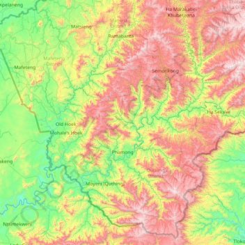
Name: Mohale's Hoek District topographic map, elevation, terrain.
Location: Mohale's Hoek District, Lesotho (-30.41483 27.17651 -29.78696 28.59184)
Average elevation: 1,944 m
Minimum elevation: 1,328 m
Maximum elevation: 3,082 m
In the southwest, Mohale's Hoek borders on South Africa: mostly the Free State Province, but the southeastern border is with the Eastern Cape Province. Domestically, it borders on the following districts, namely, Mafeteng District in northwest, Maseru District in north, Thaba-Tseka District in northeast, Qacha's Nek District in east, and Quthing District in southeast. The Western districts of Lesotho has predominantly low land zone with an elevation of 1,500 m (4,900 ft) 1,800 m (5,900 ft) above the sea level. These lands are the major agricultural zones in the country. The average annual rainfall in the country is 100 cm (39 in), most of which is received during the rainy season of October to April. Though it rains during all the months of the year, groundwater is limited on account of run-offs. The region has a temperate climate on account of the elevation and is humid during most parts of the year. The temperature in low lands vary from 32 °C (90 °F) to −7 °C (19 °F) in the winter.
Other topographic maps
Click on a map to view its topography, its elevation and its terrain.
Katse Dam
Lesotho > Thaba-Tseka District
Katse Dam, Thaba-Tseka District, Lesotho
Average elevation: 2,108 m
Ha Motheo
Lesotho > Maseru District > Temaneng
Ha Motheo, Temaneng, Maseru District, Lesotho
Average elevation: 1,779 m
Botso Water Reseviour
Botso Water Reseviour, Leribe District, Lesotho
Average elevation: 2,285 m
Mohale's Hoek
Lesotho > Mohale's Hoek District > Mohale's Hoek
Mohale's Hoek, Mohale's Hoek District, Lesotho
Average elevation: 1,661 m
Drakensberg
Drakensberg, Mokhotlong District, Lesotho
Average elevation: 3,286 m
Mokhotlong
Lesotho > Mokhotlong District > Mokhotlong
Mokhotlong, Mokhotlong District, Lesotho
Average elevation: 2,293 m
Maseru
Lesotho > Maseru District > Maseru
Maseru, Maseru District, 100, Lesotho
Average elevation: 1,606 m
Ha Long
Lesotho > Thaba-Tseka District > Ha Long
Ha Long, Thaba-Tseka District, Lesotho
Average elevation: 2,412 m
Thabana Ntlenyana
Thabana Ntlenyana, Mokhotlong District, Lesotho
Average elevation: 3,313 m
Wilson's Peak
Lesotho > Thaba-Tseka District
Wilson's Peak, Thaba-Tseka District, Lesotho
Average elevation: 2,915 m