
Naucalpan de Juárez topographic map
Interactive map
Click on the map to display elevation.
About this map
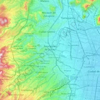
Name: Naucalpan de Juárez topographic map, elevation, terrain.
Location: Naucalpan de Juárez, State of Mexico, Mexico (19.41201 -99.41407 19.53669 -99.20673)
Average elevation: 2,366 m
Minimum elevation: 2,230 m
Maximum elevation: 2,905 m
The highest peaks are the Organo and La Malinche mountains at 3,650 metres (11,980 feet) above sea level. Other notable elevations include la Cantera, El Cedral, San Joselito, La Plantación and Peña del Rayo. The main rivers through the area include the Totolina, San Lorenzo and Los Remedios. Water supply for the municipality is supplemented by 28 deep wells, and an aqueduct that brings water from the Lerma River. It has a temperate climate with a rainy season in the summer and early fall. Freezing temperatures occur between November and February, but the last significant snowfall occurred in 1967. Vegetation outside the city proper consists of conifers and oaks, with orchards of fruit trees such as plums, apples and pears. Most wildlife consists of small mammals such as squirrels and opossums along with small reptiles and birds. However, deforestation is a major problem. There are eight ejidos, five of which are dedicated to agriculture and the rest to other activities. Agricultural production includes animal feed, barley, beans, corn, wheat, avocados, peaches and cactus fruit. Livestock includes cattle, pigs, sheep and domestic fowl. There is also some trout farming. Building stone, sand and gravel are still mined here. However, the overwhelming majority of the municipality's economic activity is the industry and commerce in the city proper.
Other topographic maps
Click on a map to view its topography, its elevation and its terrain.
Nevado de Toluca
Mexico > State of Mexico > Toluca
Nevado de Toluca, Toluca, State of Mexico, Mexico
Average elevation: 4,280 m
Jilotepec
Jilotepec, State of Mexico, 54270, Mexico
Average elevation: 2,577 m
Huitznahuac
Mexico > State of Mexico > Chiautla
Huitznahuac, Chiautla, State of Mexico, 52270, Mexico
Average elevation: 2,253 m
Toluca
Mexico > State of Mexico > Toluca
Toluca, State of Mexico, 50000, Mexico
Average elevation: 2,729 m
Nezahualcóyotl
Nezahualcóyotl, State of Mexico, Mexico
Average elevation: 2,235 m
Lerma
Mexico > State of Mexico > Lerma
Lerma, State of Mexico, 52006, Mexico
Average elevation: 2,752 m
Parque Nacional Molino de Flores Netzahualcoyotl
Mexico > State of Mexico > Texcoco > Xocotlán
Parque Nacional Molino de Flores Netzahualcoyotl, Xocotlán, Texcoco, State of Mexico, Mexico
Average elevation: 2,313 m
Parque de Bosques de Uganda
Mexico > State of Mexico > Nezahualcóyotl
Parque de Bosques de Uganda, Colonia Bosques de Aragón, Nezahualcóyotl, State of Mexico, 57170, Mexico
Average elevation: 2,229 m
San Franciso de Asís
Mexico > State of Mexico > San Franciso de Asís
San Franciso de Asís, State of Mexico, Mexico
Average elevation: 890 m
Ecatepec de Morelos
Ecatepec de Morelos, State of Mexico, Mexico
Average elevation: 2,288 m
San Lorenzo Tlalmimilolpan
Mexico > State of Mexico > San Lorenzo Tlalmimilolpan
San Lorenzo Tlalmimilolpan, Teotihuacán, State of Mexico, 55845, Mexico
Average elevation: 2,274 m