Geolocate

Viti Levu topographic map

Interactive map

Click on the map to display elevation.

About this map

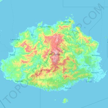
Name: Viti Levu topographic map, elevation, terrain.

Location: Viti Levu, Western, Fiji (-18.27570 177.24305 -17.31103 178.69579)

Average elevation: 112 m

Minimum elevation: -2 m

Maximum elevation: 1,285 m

Other topographic maps

Click on a map to view its topography, its elevation and its terrain.

Nawaka Village

Fiji > Western > Nawaka Village

Nawaka Village, Western, Fiji

Average elevation: 12 m

Lautoka

Fiji > Western > Lautoka

Lautoka, Western, Fiji

Average elevation: 88 m

Viti Levu

Fiji > Western

Viti Levu, Western, Fiji

Average elevation: 359 m

Yasawa Island

Fiji > Western

Yasawa Island, Western, Fiji

Average elevation: 3 m

Nadi

Fiji > Western > Ba

Nadi, Ba, Western, Fiji

Average elevation: 114 m