Geolocate

Mingulay topographic map

Interactive map

Click on the map to display elevation.

About this map

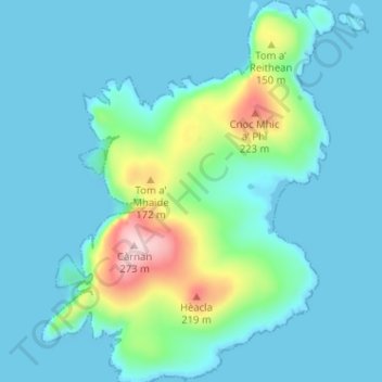
Name: Mingulay topographic map, elevation, terrain.

Location: Mingulay, Western Isles, Scotland, United Kingdom (56.79597 -7.66659 56.83098 -7.61831)

Average elevation: 43 m

Minimum elevation: -1 m

Maximum elevation: 271 m

Other topographic maps

Click on a map to view its topography, its elevation and its terrain.

Spin

United Kingdom > Scotland > Western Isles

Spin, Western Isles, Scotland, HS8 5SN, United Kingdom

Average elevation: 241 m

Reef

United Kingdom > Scotland > Western Isles

Reef, Western Isles, Scotland, HS2 9HU, United Kingdom

Average elevation: 18 m

St Kilda

United Kingdom > Scotland > Western Isles

St Kilda, Western Isles, Scotland, United Kingdom

Average elevation: 11 m

Balranald

United Kingdom > Scotland > Western Isles > Balranald

Balranald, Western Isles, Scotland, HS6 5DW, United Kingdom

Average elevation: 13 m