
Make a donation
Gear up for your next adventure:
As an Amazon Associate, this site earns from qualifying purchases at no extra cost to you.
Mount Boyce topographic map
Click on the map to display elevation.
Make a donation
Gear up for your next adventure:
As an Amazon Associate, this site earns from qualifying purchases at no extra cost to you.
About this map
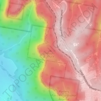
Name: Mount Boyce topographic map, elevation, terrain.
Average elevation: 922 m
Minimum elevation: 674 m
Maximum elevation: 1,089 m
New South Wales trails, hiking, mountain biking, running and outdoor activities
Make a donation
Gear up for your next adventure:
As an Amazon Associate, this site earns from qualifying purchases at no extra cost to you.
Other topographic maps
Click on a map to view its topography, its elevation and its terrain.
Grose Valley
Australia > New South Wales > Blackheath
The bulk of the vegetation in the wilderness is dry open forest and woodland, dominated by Eucalyptus sieberi and E. piperita above 800 metres (2,600 ft) altitude with Eucalyptus oblonga, E. globoidea, E. agglomerata and Angophora costata becoming dominant at lower altitudes. Plateau areas have thinner or…
Average elevation: 833 m