
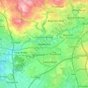
Heywood topographic map
Interactive map
Click on the map to display elevation.
About this map
Name: Heywood topographic map, elevation, terrain.
Average elevation: 146 m
Minimum elevation: 66 m
Maximum elevation: 307 m
Other topographic maps
Click on a map to view its topography, its elevation and its terrain.
London
London's topography is characterized by a gently rolling terrain shaped by the River Thames and its tributaries. The city lies within the London Basin, a natural depression bordered by higher grounds such as the North Downs to the south and the Chiltern Hills to the northwest. The Thames flows west to east,…
Average elevation: 66 m
South East England
Near Weybridge are the UK headquarters of Sony with SSP Group (situated in Byfleet) and Procter & Gamble (next door to each other on The Heights Business Park near the former Brooklands racing circuit) with Kia Motors UK and Petroleum Geo-Services UK, and Gallaher Group (cigarettes) is to the north, next to…
Average elevation: 69 m
Birmingham
Birmingham is a snowy city relative to other large UK conurbations, due to its inland location and comparatively high elevation. Between 1961 and 1990 Birmingham Airport averaged 13.0 days of snow lying annually, compared to 5.33 at London Heathrow. Snow showers often pass through the city via the Cheshire gap…
Average elevation: 138 m
Bath
United Kingdom > England > Bath and North East Somerset
Bath is in the Avon Valley and is surrounded by limestone hills as it is near the southern edge of the Cotswolds, a designated Area of Outstanding Natural Beauty, and the limestone Mendip Hills rise around 7 miles (11 km) south of the city. The hills that surround and make up the city have a maximum altitude…
Average elevation: 100 m
Cambridgeshire
Cambridgeshire has a maritime temperate climate which is broadly similar to the rest of the United Kingdom, though it is drier than the UK average due to its low altitude and easterly location, the prevailing southwesterly winds having already deposited moisture on higher ground further west. Average winter…
Average elevation: 32 m
Ipswich
United Kingdom > England > Suffolk
Ipswich experiences an oceanic climate, like the rest of the British Isles, with a narrow range of temperature and rainfall spread evenly throughout the year. One of the two nearest for which data is available is East Bergholt, about 7 miles (11 km) south west of the town centre and at a similar elevation, and…
Average elevation: 29 m
Kent
Kent was also the location of the largest number of art schools in the country during the nineteenth century, estimated by the art historian David Haste, to approach two hundred. This is believed to be the result of Kent being a front line county during the Napoleonic Wars. At this time, before the invention…
Average elevation: 37 m
Cornwall
The interior of the county consists of a roughly east–west spine of infertile and exposed upland, with a series of granite intrusions, such as Bodmin Moor, which contains the highest land within Cornwall. From east to west, and with approximately descending altitude, these are Bodmin Moor, Hensbarrow north…
Average elevation: 55 m
Cheriton Fitzpaine
United Kingdom > England > Devon > Mid Devon > Cheriton Fitzpaine
Average elevation: 143 m
Cirencester
United Kingdom > England > Gloucestershire > Cotswold District > Chesterton
On Cotswold Avenue is the site of a Roman amphitheatre which, while buried, retains its shape in the earthen topography of the small park setting. Cirencester was one of the most substantial cities of Roman-era Britain.
Average elevation: 128 m
Tiddesley Wood
United Kingdom > England > Worcestershire > Wychavon > Pershore > Pensham
Average elevation: 28 m
East of England
The East of England region has the lowest elevation range in the UK. Twenty percent of the region is below mean sea level, most of this in North Cambridgeshire, Norfolk and on the Essex Coast. Most of the remaining area is of low elevation, with extensive glacial deposits. The Fens, a large area of reclaimed…
Average elevation: 39 m
Cambridge
United Kingdom > England > Cambridgeshire
The city, like most of the UK, has a maritime climate highly influenced by the Gulf Stream. Located in the driest region of Britain, Cambridge's rainfall averages around 570 mm (22.44 in) per year, around half the national average, The driest recent year was in 2011 with 380.4 mm (14.98 in) of rain at the…
Average elevation: 18 m
Yorkshire
In Yorkshire there is a very close relationship between the major topographical areas and the geological period in which they were formed. The Pennine chain of hills in the west is of Carboniferous origin. The central vale is Permo-Triassic. The North York Moors in the north-east of the county are Jurassic in…
Average elevation: 130 m
Balderton
United Kingdom > England > Nottinghamshire > Newark and Sherwood > Balderton
Average elevation: 20 m
Suffolk
The west of the county lies on more resistant Cretaceous chalk. This chalk is responsible for a sweeping tract of largely downland landscapes that stretches from Dorset in the south west to Dover in the south east and north through East Anglia to the Yorkshire Wolds. The chalk is less easily eroded so forms…
Average elevation: 35 m
Exeter
United Kingdom > England > Devon
The city of Exeter was established on the eastern bank of the River Exe on a ridge of land backed by a steep hill. It is at this point that the Exe, having just been joined by the River Creedy, opens onto a wide flood plain and estuary which results in quite common flooding. Historically this was the lowest…
Average elevation: 56 m
Cambridge
United Kingdom > England > Cambridge
The city, like most of the UK, has a maritime climate highly influenced by the Gulf Stream. Located in the driest region of Britain, Cambridge's rainfall averages around 570 mm (22.44 in) per year, around half the national average, with some years occasionally falling into the semi-arid (under 500 mm (19.69…
Average elevation: 18 m
Worthington
United Kingdom > England > Leicestershire > North West Leicestershire
Average elevation: 103 m
Scredington
United Kingdom > England > Lincolnshire > North Kesteven > Scredington
Average elevation: 13 m
Plymouth
The River Plym, which flows off Dartmoor to the north-east, forms a smaller estuary to the east of the city called Cattewater. Plymouth Sound is protected from the sea by the Plymouth Breakwater, in use since 1814. In the Sound is Drake's Island which is seen from Plymouth Hoe, a flat public area on top of…
Average elevation: 46 m
Somerset
Many settlements developed because of their strategic importance in relation to geographical features, such as river crossings or valleys in ranges of hills. Examples include Axbridge on the River Axe, Castle Cary on the River Cary, North Petherton on the River Parrett, and Ilminster, where there was a…
Average elevation: 96 m
Staunton Harold Reservoir
United Kingdom > England > Derbyshire > South Derbyshire > Melbourne CP
Average elevation: 93 m
Lake District National Park
The Lake District is a roughly circular upland massif, deeply dissected by a broadly radial pattern of major valleys which are largely the result of repeated glaciations over the last 2 million years. The apparent radial pattern is not from a central dome, but from an axial watershed extending from St Bees…
Average elevation: 206 m